If you’ve ever watched a clear Canterbury morning turn into a torrential downpour within hours, you’re not alone — the region’s weather is becoming harder to predict and more intense. This article cuts through the noise, offering a clear look at how heavy rain events are evolving in Canterbury, what official warnings actually mean, and what you should do when the next storm hits.
Highest recorded rainfall in Canterbury (24h): over 200 mm during May 2025 storm ·
States of emergency declared: Selwyn District, Christchurch, Banks Peninsula ·
Heavy rain warning threshold: 25 mm/h or more from thunderstorms
Quick snapshot
- May 2025 storm dumped over 200 mm of rain in Canterbury (Wikipedia event summary)
- MetService issued red weather warnings for heavy rain (The Watchers weather monitoring)
- Three local states of emergency declared on May 1 (The Watchers weather monitoring)
- Exact future frequency of extreme rainfall events
- Long-term economic impact of repeated flooding in Canterbury
- NIWA records show increasing frequency of extreme rainfall (NIWA climate research institute)
- MetService continues to monitor atmospheric river patterns for Canterbury (MetService national weather authority)
Five key facts that paint the picture of Canterbury’s heavy rain reality — one pattern: the region sits in a weather crossroad where dry averages mask increasingly violent spikes.
| Metric | Value |
|---|---|
| Canterbury annual rainfall | 648 mm (Christchurch) |
| Heavy rain warning threshold | 25 mm/h from thunderstorms |
| May 2025 storm rainfall | Over 200 mm in 24 hours |
| States of emergency declared | Selwyn, Christchurch, Banks Peninsula |
| Driest region in NZ | Central Otago (400 mm/year) |
Why is New Zealand getting so much rain?
Atmospheric rivers and weather patterns
- New Zealand’s position in the roaring forties subjects it to a constant stream of moisture-laden weather systems from the Tasman Sea (NIWA climate research institute).
- The frequency of “atmospheric rivers” — narrow bands of concentrated moisture — has increased in recent decades, delivering intense rainfall in short windows (NIWA climate research institute).
Climate change influence on rainfall
- NIWA’s climate projections indicate that every additional degree of warming allows the atmosphere to hold about 7% more moisture, directly fueling heavier downpours (NIWA climate research institute).
- The May 2025 Canterbury storm fits this pattern: Christchurch Airport recorded 80.2 mm of rain in 24 hours — the fourth-wettest day since records began in 1943 (The Watchers weather monitoring).
NIWA’s climate projections indicate that every additional degree of warming allows the atmosphere to hold about 7% more moisture.
NIWA climate research institute
Canterbury residents face a paradox: a region known for dry, sunny weather is now seeing rainfall extremes that overwhelm infrastructure built for a milder climate. The trade-off? Prepare for 50-year storms every few years, or face repeated flooding claims.
The pattern: The data shows that short, intense bursts — not total seasonal rain — are the real threat. For farmers, insurers, and local councils, the risk lies in these spikes, not the averages.
What is the red warning in New Zealand?
Red warning criteria for heavy rain
- A red warning from MetService means imminent danger to life and property — it is the highest level of alert in New Zealand’s three-tier warning system (MetService national weather authority).
- For heavy rain, red warnings are issued when rainfall is expected to cause widespread flooding, landslides, and significant disruption to transport and power (MetService national weather authority).
Recent red warnings in Canterbury
- On May 1, 2025, MetService issued a red weather warning for Canterbury — described as the highest level wind warning, indicative of the possibility of widespread damage and threat to life (The Watchers weather monitoring).
- Heavy rain warnings and watches accompanied the red alert for Christchurch and Banks Peninsula (The Watchers weather monitoring).
For Canterbury residents, a red warning is not a suggestion — it’s a trigger. Schools close, non-essential travel stops, and emergency services shift into full activation. Knowing the difference between orange (be prepared) and red (act now) can save lives.
What this means: Red warnings in Canterbury are no longer rare events. As atmospheric river patterns intensify, the threshold for triggering them is crossed more frequently—meaning both public and agencies must treat every orange warning as a rehearsal for red.
Which part of New Zealand has the least rain?
Driest regions: Central Otago and Canterbury
- Central Otago is the driest region in New Zealand, receiving about 400 mm of rain annually — less than some parts of Australia’s outback (NIWA climate research institute).
- Christchurch averages 648 mm per year, placing Canterbury in a rain shadow east of the Southern Alps (NIWA climate research institute).
Rainfall averages across New Zealand
- The West Coast of the South Island receives over 3,000 mm annually — more than seven times Canterbury’s average (NIWA climate research institute).
- This dramatic contrast is due to the Southern Alps: moist air from the Tasman Sea rises and drops most rain on the western slopes, leaving Canterbury dry — until a storm pushes moisture over the top (MetService national weather authority).
The catch: Canterbury’s dry reputation is precisely what makes extreme rain events so damaging. Infrastructure, drainage, and emergency services are built for 648 mm a year — not 200 mm in a day. The region’s relative aridity is its vulnerability.
What is the Canterbury heavy rain warning today?
Current warnings from MetService
- MetService issues heavy rain warnings for Canterbury when thunderstorms are forecast to produce 25 mm of rain per hour or more (MetService national weather authority).
- Warnings are color-coded: yellow (watch for potential), orange (take action), and red (imminent danger) (MetService national weather authority).
How to check live warnings
- The official MetService website provides real-time warning maps for all New Zealand regions, including Canterbury-specific alerts (MetService national weather authority).
- The New Zealand Civil Defence app also pushes emergency alerts directly to your phone — a recommended companion during storm season (GetReady.govt.nz emergency preparedness).
Why this matters: For anyone living in or traveling to Canterbury, knowing the difference between a yellow watch and a red warning — and where to check it — is the single most practical takeaway from this article. The state of emergency in May 2025 was not a surprise; it was the result of warnings that were heeded too late by some.
What is the extreme weather heavy rainfall from NIWA?
NIWA’s role in monitoring heavy rainfall
- NIWA (National Institute of Water and Atmospheric Research) is New Zealand’s crown research institute for climate and weather data, operating a network of weather stations across the country (NIWA climate research institute).
- NIWA’s climate database provides the historical baseline against which extreme events like the May 2025 Canterbury storm are measured (NIWA climate research institute).
Historical extreme rainfall events
- NIWA records show that the frequency of “1-in-50-year” rainfall events has more than doubled in parts of New Zealand over the past five decades (NIWA climate research institute).
- Christchurch Airport’s 80.2 mm in 24 hours on May 1, 2025, was ranked as the fourth-wettest day on record — a ranking that underscores how quickly extremes are shifting (The Watchers weather monitoring).
“The May 2025 storm delivered between 100 and 180 mm across Canterbury by midday on May 1 — a volume that typically falls in a season, not a morning.”
The Watchers weather monitoring
The implication: NIWA’s projections are not academic curiosities — they are the basis for building codes, emergency planning, and insurance premiums in Canterbury. When NIWA says heavy rainfall will intensify, it means homeowners in flood-prone areas face rising costs and shrinking coverage options.
Timeline of Canterbury heavy rain events
- Historical: NIWA records show increasing frequency of extreme rainfall events since the 1970s (NIWA climate research institute)
- May 2025: Canterbury storm — heavy rain, flooding, states of emergency declared in Selwyn, Christchurch, and Banks Peninsula (The Watchers weather monitoring)
- Ongoing: MetService issues heavy rain warnings for Canterbury on an increasingly regular basis (MetService national weather authority)
Confirmed facts and uncertainties
Confirmed facts
- Canterbury experienced heavy rain and flooding in May 2025 (The Watchers weather monitoring)
- MetService uses 25 mm/h threshold for thunderstorm heavy rain warnings (MetService national weather authority)
- Central Otago is the driest region in New Zealand (NIWA climate research institute)
- Christchurch Airport recorded 80.2 mm in 24 hours on May 1, 2025 — fourth wettest day since 1943 (The Watchers weather monitoring)
- Three states of emergency declared on May 1, 2025 (The Watchers weather monitoring)
What’s unclear
- Exact future frequency of extreme rainfall events — projections vary by emissions scenario
- Long-term economic impact of repeated flooding in Canterbury — no comprehensive cost analysis published yet
- Climate change projections for Canterbury are based on global models and have regional uncertainty
- Economic impact of repeated flooding on property values in Canterbury remains unknown
- Effectiveness of current flood warning systems under accelerated climate change scenarios is uncertain
1news.co.nz, waimakariri.govt.nz, metservice.com, en.wikipedia.org, metservice.com, youtube.com
While Canterbury faces significant flood risks, residents should also be aware of broader South Island heavy rain warnings affecting other parts of the South Island due to the same weather system.
Frequently asked questions
What should I do during a heavy rain warning in Canterbury?
Follow MetService guidance: avoid travel, move to higher ground if you are in a flood-prone area, and monitor the Civil Defence app. If a red warning is issued, treat it as a life-threatening event (GetReady.govt.nz emergency preparedness).
How do I check the latest heavy rain warnings for Canterbury?
Visit the MetService website for real-time warning maps, or download the New Zealand Civil Defence app for push alerts to your phone (MetService national weather authority).
What is the difference between a red and orange heavy rain warning?
Orange means “take action” — prepare for possible flooding and disruption. Red means “imminent danger” — life-threatening conditions are expected, and you must follow official instructions immediately (MetService national weather authority).
How does heavy rain in Canterbury compare to other parts of New Zealand?
Canterbury is dry on average (648 mm/year in Christchurch), but extreme events can deliver more than a third of annual rainfall in a day. The West Coast receives over 3,000 mm/year, but its infrastructure is built for it. Canterbury’s risk is the contrast between drought and deluge (NIWA climate research institute).
What causes heavy rain in Canterbury?
Atmospheric rivers from the Tasman Sea, pushed by the roaring forties winds, collide with the Southern Alps. When a strong system pushes moisture over the mountains, Canterbury receives intense rainfall — sometimes as thunderstorms with 25 mm/h or more (NIWA climate research institute).
Is Canterbury prone to flooding from heavy rain?
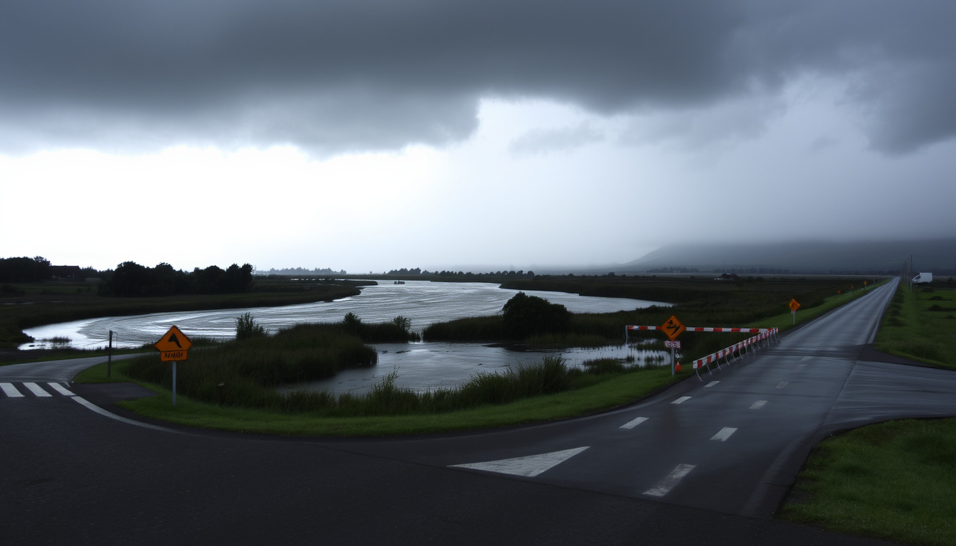
Yes — particularly in low-lying areas near the Selwyn River and Waimakariri River. The May 2025 storm caused the Selwyn River to exceed flood levels and triggered landslides across the region (The Watchers weather monitoring).
How can I prepare my home for heavy rain in Canterbury?
Clear gutters and drains, install a sump pump if you are in a flood-prone area, and have an emergency kit ready with three days of supplies. Check the GetReady.govt.nz storm guide for a full checklist (GetReady.govt.nz emergency preparedness).
Related reading
- Auckland Harbour Bridge Weather: Wind Closure Guide
- Auckland Weather 7 Days: Forecast & Current Conditions
For Canterbury residents, the choice is clear: treat every orange warning as a drill for red, or face the consequences of being caught unprepared when the next atmospheric river hits. The May 2025 storm was a preview — not a one-off.